The decision of environmental problems with the help of non-standard geophysical methods
In the stories of the people travelling on deserts, such riddle of a nature as shifting sands frequently is mentioned. The equal surface of sand after anyone mechanical influence on sand suddenly is converted to funnel, and sucks the unfortunate traveller, camel, or automobile. However it was found the similar phenomena not a rarity outside deserts. The truth, pernicious action of funnels thus is not so prompt. But so inevitably.
Till now on the Earth there are some mysterious places in which with engineering constructions, and sometimes, and with people from time to time there are unexpected events.
According to existing rules if the output of a core is decreased it testifies exclusively to poor-quality drilling. Therefore, when such occurs, in geological document this fact is absent. It has interested us because in a zone where it was not possible to take at drilling of rocks, further, in 1995 has taken place break of tunnels. That is that failure, because of which till now between stations of underground " Lesnaya " and " square Mujestva" it is necessary to go ground transport. Whether there was it casual concurrence, or these two events had relationships of cause and effect then it was still not clear for us.
Does not passed week that in the World there were no sudden destructions of houses. One of last large events of a similar sort is destruction of the Palace of Celebrations in Jerusalem. As well as in case of the failure described in the previous paragraph on underground, the reason of destruction has remained unknown. However the commission working there has presented happened as result of defects at construction. As experience shows, practically all cases of sudden destructions are explained as result of application of a poor-quality building material, or infringement of technology at construction, or misuse of this construction.
And still, very seldom, but there are sudden destructions which it is not possible to explain the listed above reasons. So, in 1903 in Canada, suddenly has collapsed Transcons elevator. Actually, has not collapsed at all, but it practically has lain on one side within 23 hours. The elevator had the sizes in the plan 23,5х58 m and was established for stability on a ferro-concrete plate of meter thickness.
One elevator corner has gone into a ground on 8 meters, and opposite has risen upwards on 3 meters.
The commission engaging in investigation of this event, first of all has established, that the grain was filled in elevator evenly, and, hence, failure has taken place not because of its wrong using. As a result of the drilling which is carried out at engineering - geological researches before construction of elevator, it was known, that the ground was submitted dense clay 20-meter thickness, and limestone was under of it. The repeated drilling executed directly after failure, has shown, that in a zone of lowered corner of elevator the ground was submitted not dense, but rather pliable, plastic clay under which the karst was.
What it was: poor-quality drilling at engineering - geological researches therefore has remained the load-bearing ability of soil unnoticed or a condition of a ground has changed during construction of elevator and its using?
About load-bearing ability of a ground can decrease numerous cases of failures on pipelines testify. Not only that the quantity of these failures is extremely great (according to ecologists, within one year the quantity of failures on various pipelines in Russia makes approximately 80 thousand), but many of them occur repeatedly in the same place, and where at engineering - geological researches the ground was characterized by sufficient durability, after failure, at repeated drilling - it is essential smaller.
It is known, that failures on pipelines always are explained by insufficient quality of pipes. But then there is a following question.The durability of a pipe in the repair place should be certainly above, than on the other sites. Then why repeated failure occurs in the same place?
In favour of the reason of sudden destructions of constructions somehow is connected to presence of sites with lowered, and I would tell, that with chronically lowered bearing ability of a ground, apparently, caused by any specific geological structure, is the fact testifies also still, that the flexure on railways occurs, as a rule, on the same sites. Repair of a site of a way is accompanied by additional condensation of a ground, but, despite of it, after a while, this site again starts to demand the same repair.
And, at last, about health of people. As shows experience, there are certain zones, in which the people more are sick and live less. The statistical data received at supervision over health of people in houses located along Grajdansky prospectus of St. Petersburg are given that in some zones the increase of quantity of sick men with oncological and cardiovascular diseases, and also reduction of longevity is observed. These zones are geopathogenic, and presence of them is caused by specific geological structure.
As have shown the engineering - geophysical researches executed with the help of alternative seismic prospecting - a spectral seismic profilings method (SSP), a nature of zones in which it is necessary to expect sudden destructions of engineering constructions, failures on pipelines, a deflection of railway lines, and also presence of geopathogenicity, same. As appeared, formation of these zones occurs on very big depths. Therefore, in spite of the fact that the SSP method is applied already more than 5 years, for builders till now it is very difficult to take advantage of its results.
The matter is that, according to beginnings of a building science, thickness of rocks influencing reliability of building, does not exceed 10-15 m. For this reason, the failure on Transkons elevator in any way is not explained to presence under it karst just because it was on depths exceeding 20 m.
This opinion has arisen as follows.
According to existing representations, rocks have elasticity. As consequence of this assumption, influence of rock's mechanical strength on building should decrease with depth, and is especial, on a background of mountain pressure growing with depth.
Really, if to load elastic plate (for example, steel plate), the flexure of it will be so less, than more thickness of this plate.
Calculations show, that at average mechanical strength of a ground and at the average sizes and weight of a building the depth of influence should not exceed these 10 -15 m.
But it is impossible to confirm presence of elasticity of rocks by any experiments. When it is elasticity the deformations convertibility should be. However, as appeared, at loading samples of rocks the deformation arise owing to accumulation of microcracking. At removal of loadings from a sample the microcracking of a material will not decrease any more and consequently, the form and the sizes of it do not come back to the initial state of cracking.
If the rock's plate is bent as result of its loading, it is due to accumulation of microcracking. And consequently, with increase of thickness a rocky plate not the deflection of it will decrease, but only will decrease speed of accumulation of microcracking. That is speed of its destruction. And it means, that on what depth there was a karst, it sooner or later all the same will start to influence an engineering construction.
As have shown results of use of SSP method in various geological conditions, formation of potentially dangerous zones is determined not only by karsts.
Application of the SSP method allows to define properties of rocks which are determined by other methods can not be. Namely, to reveal areas, zones, the surfaces characterized by increased microcracking.
One of inevitably existing surfaces that is characterized increased microcracking, is the geological boundary between sedimentary rocks and rocks of the crystal base is. Increased microcracking of these surfaces is caused by absence of mutual penetration of sedimentary and crystal rocks.
Therefore application of SSP method allows to reveal this border, and also those sites where owing to presence of tectonic infringement the section between sedimentary and crystal rocks exists as not concrete border, but some zone.
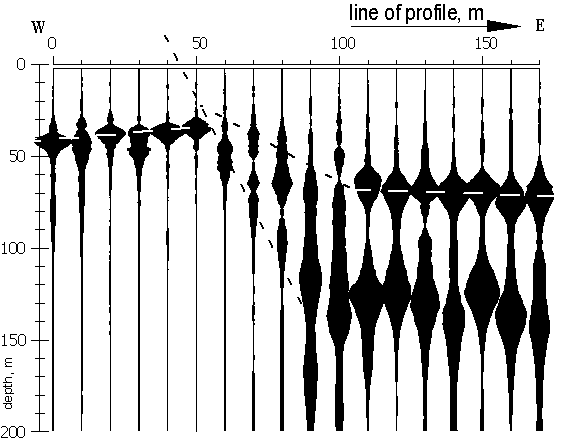
On fig. 1 the SSP-section received by seismic profiling in conditions of low thickness of sedimentary rocks, near Vyborg (Leningrad region) is given. According to the existing geological information, capacity of a sedimentary cover in this region can be from 0 up to 100 m. Crystal rocks of the base are submitted by a granite.
Each vertical object on SSP-section is the spectral image of seismic signal. The axis of frequencies is shown to the right of SSP-section. The axis of depths is at the left and is connected to an axis of frequencies at the next ratio:

at Vsh=2500 m/s.
Vsh – speed of shear waves
Sizes of bulges on each vertical object are proportional to Q-factors of a spectrum. A step of profiling - 10 m.
Before consideration of a SSP-section is necessary to make the following remark. The SSP-section represents the image of set of spectral images of seismic signals, received at profiling. That is, actually, is the image of the initial information which have been not changed by any interpretation. Due to it, at forming of SSP-section completely there is no subjective factor.
But, on the other hand, at perusal of SSP-section some skill is necessary. In this sense SSP-section can be compared to the image on the screen of the x-ray device. In this connection, for simplification of perception, on SSP-section submitted further, some geological objects will be marked.
On SSP-section submitted on fig. 1, the roof of the crystalline basement (granite) is traced. The border between rocks of the crystal base and a sedimentary cover is marked with a white shaped line.
At the western edge of a profile (0-50 m) thickness of sedimentary rock is approximately 40 m, and on east (110 - 170 m) - 70 m. On a site of a profile 60 - 100 m fractural and thrust tectonics - dump by amplitude 30м is revealed. In a zone of tectonics the roof of a granite is not traced, as the granite in this zone is characterized by blocks destruction. The area of the blocks destruction is marked by black shaped lines.
On a site of a profile 110 - 170 m in a granite on depth near 130 m the border, the nature of which to us is unknown. Usually, the same sorts of border arise, when in crystal rock massive ore bodies are deposited.
In this case the SSP method was used for searches of a deposit of artesian well, and the well on 80-th meter of a profile, from depth 40 m has given water with the debit near 100 m3 in day.
It is easy to notice, that here we have the unique information. Really, for definition of thickness of a sedimentary rock the drilling is usually used. However drilling is expensive, and wells usually are from each other on distance in some kilometers. For the revealing tectonics and to define its parameters, it would be necessary to apply it is unreal the big volume drilling and stripping works.
As has shown experience, crevice water deposits are in tectonics in the crystal base around Vyborg. For today already more than ten wells, have drilled near Vyborg on the basis of results of SSP metod, give water with the sufficient debit, and for the present there was no case when such chink would not give water.
With increase the thickness of sedimentary rock the force of pressure them to crystal rock is increased, in result of it a portrayal of border between them on SSP-section is easing.
But above a tectonic zone on SSP-section arises funnel object. Its form is caused by processes occurring in sedimentary rock in conditions, when is increased pressure of thickness from above downwards, and the monolithic crystal base is absent under them.
All this occurs as a result of absence at sedimentary rock of elastic properties. Instead of behaving like an elastic plate, that is sagged in the zone of tectonic dislocation as an iron plate, sedimentary rock that covering tectonic dislocation, is crushed by superstratum layers, and fills the breaks in the crystal base.
This process of filling of fractural tectonic represents micromovings from above downwards of sedimentary rock particles. This process covers all column of rock which are taking place directly above tectonics. However intensity of micromovings decreases from below upwards, in process of decreasing of rock pressure. For this reason the surface layer of sedimentary rock until a certain time can be strong enough.
It is clear, that in zones, where there are constant micromovings of particles, the rocks are in a condition of increased microcracking. Hence, taking place in a zone of tectonic fissure of rock, former strong then, when they still were surface, in process of increase of thickness of sedimentary rock, will be involved in process of micromovings, and by that to collapse.
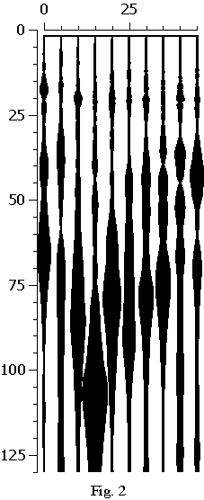 The SSP-section, given in a fig. 2, is received by profiling lengthways yet not constructed railway ways on outskirts of St.-Petersburg. Well visible here funnel-shaped the object corresponds to increased microcracking of sedimentary rock and is an information that the structure has crossed the discontinuous tectonic.
On depths about 20 м the almost horizontal border is poorly looked through. It means, that in 20-meter near-surface layer of rock any traces from taking place under them tectonic faulting still are absent.
The influence on a ground on the part of building technology, and then, on the part of the erected building will result that the top border of a rock column, within the limits of which there are micromovings particles from above downwards, will begin to rise to surface. Thus, the conducting construction work in a zone tectonic faulting necessarily will result in destruction of rock's surface layers.
After end of construction of the railway in this place and beginning of its functioning the border traced on depth 20 m, also will have the funnel-shaped form. It will testify that microcracking of rock is increased and has reached a surface, and strong before construction the rock's surface layer has lost the soil bearing capacity.
Let's pay attention on the funnel-shaped form of object is above the tectonic faulting is shown in a fig. 2. It is the same funnel, as in a case of running sand. And only presence of sticker substance between separate grains of sedimentary rock makes immersing process in a ground by considerably slower, than there, where a ground is clean sand.
The rocks which are taking place in a condition increased broken state, have also enlarged permeability both for liquid, and for gaseous matters. Therefore, if in conditions of limestone the tectonic faulting meets , and water that migrates along permeable rock has acid character, as a result of interaction it with limestone there will be a cave process. Hence, a karst - only special case of display the tectonics in conditions of limestone.
The presence of the increased permeability of rocks in joint fissure zones allows to understand physics of formation of geopathogenic zones. The using of spectral seismic prospecting in geopathogenic zones has shown, that these zones are formed directly above tectonic faulting.
The soil column is having increased gas-permiability is the channel, along which on a surface the gases move from the Earth's interior. The presence of hypogene methane, radon, carbonic acid and other gases is easily registered by any gas-analysers. The concentration of these gases is usually insignificant, but at long influence they render on our health tortious act.
The numerous supervision over behaviour of engineering structures in zones, where on SSP-section appear funnel-shaped objects, have allowed to see a lot of visual attributes of tectonic zones. It and failures of a road covering, and specific cracks in walls of houses. The cracks can be seen these under more often to corners of windows, both the intensity them and extent depends on parameters of tectonic failures.
The formation of cracks in walls, apparently, does not depend on quality стройматериалов and used building technologies. Anyway, I observed these cracks equally frequently both in Russia, and in the countries glorified by high quality of construction. In France, Belgium, Germany I saw these cracks, frequently, in walls of houses, which construction still was not finished at all. Even, moreover, in old houses penetrated through by cracks, they can be not so visible, as even special technologies allowing these cracks are created to make invisible.
However, unfortunately, the level of geopathology is not reduced after puttying of cracks not only, but also, on the contrary, is increased. Because by puttying the cracks, we, thus, increase tightness of premises and as though we promote accumulation in them of harmful substances. But also, the cracks, seen to an eye, are the indicator of a developing emergency. The cases are known for us, when the inhabitants left collapsing dwelling beforehand, were based on visually observable cracks in walls.
Does not cause doubt, that the application of a SSP method in due course will allow to reduce an accident rate of engineering structures and will raise ecological safety in inhabited and industrial premises.